

The interpretation of explosive bomb craters is an essential part of aerial photo evaluation for explosive ordnance reconnaissance. How well these objects can be recognised depends primarily on the quality and scale of the available aerial photo material. If both factors are favourable, it is usually possible to identify explosive bomb craters on the basis of their shape (ejected material, hollow form). This is particularly the case if the bombing took place shortly before the aerial photograph was taken and the funnels have not already been backfilled in the period between the drop and the aerial photograph.
Older bomb craters that have been partially or completely filled in, on the other hand, can often only be recognised as round, flat objects with blurred edges in aerial photographs taken during the war (see Fig. 1 for an example). An identification as a bomb crater is often no longer possible without doubt, especially since objects designed in this way can also be attributed to non-military circumstances.
Fig. 1 - Young and old demolition bomb funnel (source: aerial photo database)
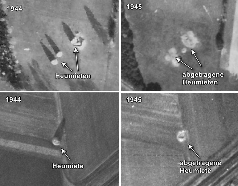
Causes of the formation of round, flat ground features with a civilian background are mainly to be found in agricultural and forestry use. For example, haystacks can easily be mistaken for older/over-imprinted bomb craters. These mostly cone-shaped piles can reach a height of 6-7 m and are easily recognisable in the aerial photograph as full forms. In the course of time, they are gradually removed, leaving behind structures that can be deceptively similar to old demolition bomb craters in aerial photographs (see Fig. 2 for an example).
Fig. 2 - Hay rents before and after a removal (source: aerial photo database)
In areas used for forestry, it is the hole-cutting (circular clearings for the regeneration of the forest stand) that creates aerial structures which - especially if they are small and irregular - can easily be mistaken for "aged" explosive bomb craters (see Fig. 3 for an example).
Fig. 3 - Hole cutting (source: aerial photo database)
Other - albeit less frequent - objects that contain potential for confusion with older/overfilled explosive bomb craters are, for example, circular field irrigation systems or old burial mounds. In both cases, flat, circular ground structures can be seen in the aerial photograph, which can bear a clear resemblance to backfilled explosive bomb craters (see Fig. 4 for an example).
Fig. 4 - Irrigation structures (top) and burial mounds (bottom) (source: aerial photo database)
Another important interpretative feature in aerial photo interpretation for the detection of bomb craters is the geometric arrangement of the respective individual objects. Thus, certain distribution patterns can give a strong indication that image contents that have typical characteristics of bomb craters in terms of shape and size can be traced back to an origin other than bomb drops.
In order to avoid confusion with image features of civilian origin when recording explosive bomb craters, it is necessary to obtain aerial photographs of several time periods in order to be able to carry out a multi-temporal comparison of the uses at the site in question. Only in this way is the prerequisite for the most reliable object identification possible; the danger of misinterpretation is minimised. A monotemporal aerial photo evaluation with consideration of a single aerial photo time slice increases the probability of misinterpretations considerably and is not to be evaluated as technically meaningful. A prerequisite in this context is the availability of the corresponding image material in the relevant archives.