

Explosive ordnance from the Second World War is still a potential risk for planned construction projects. In order to be able to assess this risk and take it into account in further planning, M&P offers its clients preliminary exploration of explosive ordnance on the basis of aerial photo evaluations. In order to prepare a more meaningful aerial photo evaluation, M&P first has the events of the attack and the war reconstructed by a company's own specialist group of historians, geographers and geoinformaticians on the basis of historical sources and specialist literature. This background information provides valuable clues in the search for ordnance-relevant objects in the aerial photograph. Conversely, the aerial photo analysis can also give impulses to the historical research for targeted, more in-depth investigations, as the example of an explosive ordnance reconnaissance in a small community in southern Germany shows.
One eyewitness account from 1945 stood out in this project. It provided detailed descriptions of a large explosion that was said to have destroyed several tons of gunpowder. Details of the approximate blast site, a forest area, as well as extensive property damage in the surrounding area were also found in the eyewitness report, which was considered credible. With such blasts, ejection radii of up to one kilometre are to be expected. Therefore, it had to be investigated whether the explosion could have ejected explosive ordnance and/or unburned explosives into the investigation area considered in the context of the preliminary investigation of explosive ordnance. The first task was to precisely locate the site of the explosion. It seemed unlikely that such an event would have left no aerial traces. However, in an aerial photograph taken only a few weeks after the blast, no evidence of an explosion crater was found despite a targeted search. The assumption was that the crater was located within a small forest that still exists today and was therefore invisible in the aerial photograph. But even a specially procured digital terrain model (DTM), which depicts today's ground structure independent of forest cover, did not provide any new clues to a possible blast site.
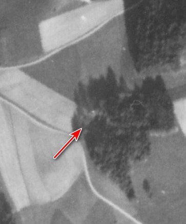
This seemed to exhaust the possibilities of aerial photo evaluation and it was still not clear whether the explosion could have resulted in an explosive ordnance load in the area of the planned construction site. The baton was therefore passed again to the team of experts for historical research. They finally succeeded in locating a contemporary witness who was able to confirm and precisely locate the blast and even clarified the question of the whereabouts of the crater. According to the witness, the former blast crater had been built over in the post-war period and could therefore neither be seen in current aerial photographs nor on the DTM. With the knowledge of the blast site, the crater could now also be located in the historical aerial photograph. It turned out that it was almost invisible in the shadow of tall trees (see figure).
Thus, thanks to M&P's various expertises and their close cooperation, it was possible to clarify the alleged contradictions. The distance of the now safely determined explosion site to the investigation area resulted in a resilient assessment of the explosive ordnance risk for the client's construction project.